News - Footpath
| Contact the news and picture editor. |


|
Themes ScotRail Aberdeen Helmsdale Edinburgh Waverley Inverness Brora RMT Ticket offices Storm Ciarán Barrhead Caledonian Sleeper Network Rail Electrification Signalling fault Glasgow Central LNER Far North Line Accessibility Dundee Sea wall Inverurie
|
A project has started to replace the wooden deck of Woodend Bridge on the multi-use path between Cardrona and Innerleithen.
It is a decade since the Tweed Valley Railway Path opened. And the suspension bridge was constructed before the route opened. The work is expected to take two weeks and cost in the region of £100,000. It will be completed by workers from Berwick-upon-Tweed firm Tweed Formwork. [This bridge replaces, on a different alignment, a missing railway bridge.] (Permalink) Cardrona Cardrona Viaduct Cyclepath Eshiels Tunnel Footpath Innerleithen Peebles Railway River Tweed Tweed Valley Railway Path  Cardrona Viaduct: A goods train going east crossing the River Tweed near Cardrona House heading for Innerleithen, thought to have been taken around 1960. The Peebles Loop closed completely in 1962.  Cardrona Viaduct: The footbridge that now spans the Tweed between Cardrona and Innerleithen, seen from the trackbed of the Peebles Railway looking towards Galashiels in June 2014. The long demolished railway bridge sto ... 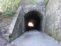 Eshiels Tunnel: The 70 yard long former railway tunnel under the A72 Innerleithen Road at Eshiels, just east of Peebles, photographed in July 2010. Sealed in 1962, the tunnel was reopened as part of a cycle route ear ... |
|
|
|
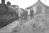
One trainspotter said extending the railway line would be 'the creme de la creme' for tourists and rail enthusiasts alike.
(Permalink) Brechin Cyclepath Footpath Montrose  Montrose: An Aberdeen to Glasgow service pulls into Montrose on 13 February 2019. '3 carriages - apologies' announces the departures screen, a familiar message on this and the Highland Main Line in the absence ... 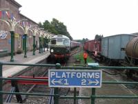 Brechin: D5314 prepares to run round the stock of the 12.20 for Bridge of Dun at Brechin on 1st September 2018.
|
|
A station for Parkhead and a nearby old railway line being transformed into a cycle path are new plans emerging to improve East End areas. [A replacement station at Parkhead North, closed 1955, has been proposed many times along with a footpath utilising the former Switchback. The first proposal to re-open the station was in 1964 when Parkhead Stadium station and the GCR closed. See map for 2008 proposal. -RS]
(Permalink) Cyclepath Footpath Hogarth Park New station Parkhead Parkhead North Re-opening The Switchback  Parkhead Junction [CR]: Looking up to Switchback Line...notice the plyon and flats in background.  Parkhead North: N2 0-6-2T 69507 passing the site of Parkhead North station in May 1958 with a Hyndland - Shettleston train. The bridge in the background carried the Switchback over the formation, while that to the le ...  Parkhead Junction [CR]: Extract from Glasgow City Council plans for the East End Regeneration showing the proposed route over the former Switchback (Caledonian Railway) and the planned new Station at Parkhead Forge. |
|
Plans have been lodged with Perth and Kinross Council showing how new bridges will be installed along a former railway line to make a multi-purpose route connecting Comrie and Crieff.
(Permalink) Comrie Crieff Cyclepath Footpath  Strowan Tunnel: The east end of Strowan Tunnel, between [[Crieff [2nd] ]] and [[Comrie]]. 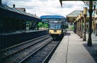 Crieff [2nd]: An unidentified Park Royal railbus, on the Crieff-Gleneagles run, seen at Crieff station in the early 1960s. The view looks west. Some cutting back of the station has taken place. Note the demolished ... 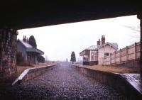 Comrie: Easter 1966, just two years after closure, with the track not long lifted, but the former Comrie station is already showing signs of decay. Originally part of the Caledonian Railway route from Perth t ... |
|
Active outdoors: John Davidson enjoys a family walk from the forest village in a visit to the Cairngorms national park.
(Permalink) Footpath Nethybridge Timber Extraction Railway Timber Wartime 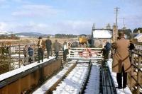 Nethy Bridge: Looking north over the level crossing at Nethy Bridge on 2 November 1968 as a special makes a photostop at the closed station. The special, which was on its way to Aviemore, was organised to mark the ... |
|
The firm behind a multi-million-pound restoration of a popular railway trail which was destroyed by flooding has won an award for its work.
(Permalink) Keswick and Penrith Railway Civil Engineering Contractors Association Cockermouth Cubby Construction Flooding Footpath  Keswick: After passing through the now infilled tunnel see image [[39079]], passengers for Keswick crossed the River Greta at an angle, on an inverted bowstring girder bridge. This view looks South West along ...  Threlkeld: The remains of Threlkeld's island platform in 2013, forty one years after final closure. View looking east towards Troutbeck and Penrith with the council depot that occupies the old goods yard also vi ... 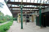 Keswick: The closed station at Keswick looking east in September 2006, approximately 34 years after closure. The station is intended to be used as the terminus if the line ever re-opens. See image [[11717]] |
|
More than £2 million of funding has been secured for the creation of an 'active' travel path between Peebles and Eddleston.
(Permalink) Cyclepath Eddleston Footpath Greenway Peebles  Peebles [2nd]: The former goods office and weighbridge at Peebles, currently standing at the north end of Edinburgh Road car park - still referred to as East Station car park in some quarters see image [[29054]]. Th ...  Eddleston: Modified TV aerial mast alongside a former crossing keeper's cottage on the Peebles Railway just north of Eddleston in March 2008. |
|
Carlton Reid rode along theBowes and the Tanfield railway paths close to Newcastle, the latter running along a waggonway route that dates back to the 1620s.
(Permalink) Bowes Railway Causey Arch Cyclepath Footpath Pontop and Jarrow Railway Tanfield Railway 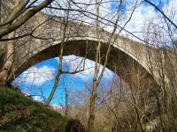 Causey Arch: The historic Causey Arch on the Tanfield Railway in March 2013. Dating from 1725, it is the world's oldest surviving single arch railway bridge. See image [[41776]] 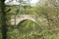 Causey Arch: The historic Causey Arch in May 2006, seen from alongside the trackbed of the Tanfield Railway. See image [[41776]] |
|
Lothian MSP Miles Briggs says he is disappointed that the project to transform the Powderhall Railway path into a green corridor has been delayed due to the Spaces for People initiative. In a letter to Mr Briggs, from The City of Edinburgh Council, the Active Travel Department said that 'Progress on this has been delayed by the need to re-allocate staff resources to develop and deliver temporary Spaces for People (SfP) schemes'.
(Permalink) Cyclepath Easter Road Deviation (North British Railway) Footpath Greenway Miles Briggs Powderhall |
|
Engineers are carrying out repair work on a former railway viaduct in north Northumberland.
(Permalink) Footpath Twizel Viaduct Twizell |
|
Taking the railway path from Clackmannan, and heading eastwards towards Brucefield, a white glimmer caught my eye amongst the dark tangled branches.
(Permalink) Clackmannan Footpath Stirling and Dunfermline Railway |
|
The potential conversion of old railway lines into cycle and walking routes is being blocked by plans to infill more than 100 bridges, including more than 20 in Scotland, campaigners have claimed.
(Permalink) At risk Footpath Highways England cyclepath 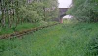 Uplawmoor [1st]: A view of the concrete southbound platform at Uplawmoor taken from the remains of the northbound platform. To the north/east of here the trackbed remained in a remarkable state of preservation for sev ... |
|
Plans to use an old railway line to create a new path linking Neilston and Uplawmoor for walking, cycling and wheeling are firmly on track.
(Permalink) Footpath Lanarkshire and Ayrshire Railway Neilston Uplawmoor Uplawmoor [1st]: A view of the concrete southbound platform at Uplawmoor taken from the remains of the northbound platform. To the north/east of here the trackbed remained in a remarkable state of preservation for sev ... 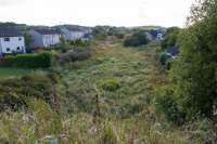 Neilston: With the buffer at Neilston at my back this is the view towards Uplawmoor showing the disused trackbed. This was still easily walkable for miles in the 1980s, looks trickier now.  Uplawmoor [1st]: BR Standard class 4 2-6-4T 80113 reaches the end of its journey as it runs into Uplawmoor station on 11 July 1956 with the 5.42pm train from Glasgow Central. |
|
Nearly 5,000 people have signed a petition to stop a rail route being reinstated over a landmark viaduct.
The Manchester and East Midlands Rail Action Partnership (MEMRAP) has campaigned for the Peaks and Dales line to reopen between Matlock and Buxton. The line includes the Monsal Viaduct in Derbyshire, which has been converted into a walking and cycling trail. (Permalink) Footpath Monsal Dale Viaduct Monsal Trail 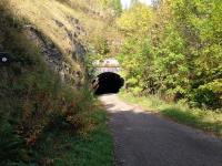 Cressbrook Tunnel: Approaching Cressbrook Tunnel on the Monsal Trail heading west on 28 September 2014. 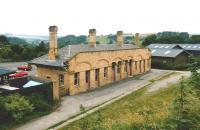 Bakewell: Main building of the former Midland railway station at Bakewell seen here platform side in July 1991. View is from the adjacent overbridge looking towards Buxton. Bakewell station closed to passengers ... 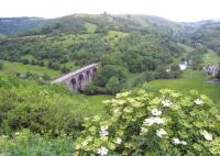 Monsal Dale Viaduct: Looking west into Monsal Dale on 17 June 2012 with the former Midland Railway viaduct crossing the River Wye in the centre. To the left the railway entered Headstone Tunnel while in the middle distanc ... |
|
A bid to transform a disused railway from Ayr to Girvan into a safe active travel route has gathered pace during lockdown with the council backing ambitious plans.
(Permalink) Footpath Maidens and Dunure Light Railway 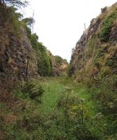 Dunure: A rather boggy cutting just south of the station site at Dunure in 2005. 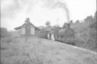 Maidens: Maidens (passing loop still in place). |
|
The section of railway between Keswick and Threlkeld in the Lake District was closed in 1972 and subsequently became a well-used footpath. However two striking bowstring bridges were washed away during Storm Desmond in 2015, severing the route and impacting on local tourism. The structures had been engineered by Sir Thomas Bouch whose reputation was ...
(Permalink) Footpath Keswick: After passing through the now infilled tunnel see image [[39079]], passengers for Keswick crossed the River Greta at an angle, on an inverted bowstring girder bridge. This view looks South West along ... 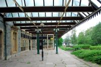 Keswick: Keswick looking west. The island platform has gone (it was to the right) and the site is now a carpark. But there is a plan to re-open the line ... 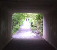 Keswick: This concrete box tunnel under the Keswick bypass is handy for cyclists and pedestrians following the Keswick branch trackbed, and could conceivably help reopening. But the upward slope in the backgro ... |
|
The uneconomical coastal line was closed during the Beeching axe period in the 1960s, and by 1972 all of the track had been removed. The route remained as a designated greenway for walking, cycling and horse riding and was named the Cinder Track.
However, the path was neglected for years and struggled to fulfil its potential for recreation and tourism. In 2019, an ambitious scheme to restore the condition of the Cinder Track began and the first stage is now complete, although a ceremony planned to mark the milestone has had to be postponed due to the lockdown restrictions. (Permalink) Footpath  Cloughton: Despite the bench sporting a Goathland nameplate, the converted station is actually Cloughton on the closed Whitby - Scarborough line. Photographed looking south along the platform on 20 April 2009. W ... 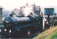 Robin Hood^s Bay: The RCTS North Eastern Limited calls at Robin Hood's Bay on 2 May 1964 on its way from Newcastle to Whitby. B1 61031 Reedbuck had taken over the train at York. See image [[26270]] for a ... |
|
Work has begun on a new footpath with several viewing areas overlooking the iconic Glenfinnan Viaduct.
Passenger numbers to the west Highland station have doubled in the last 10-years, with over 11,000 visitors in 2017-18 flocking to the area to catch a glimpse of a train crossing the A-listed structure made famous by the success of the Harry Potter films. Many other tourists stop off at Glenfinnan on their journey to Mallaig to view the station museum, viaduct and monument to the Jacobite rising. (Permalink) Footpath Glenfinnan Viaduct |
|
Three years after a study earmarked five disused Welsh railway tunnels for reopening as cycling and walking routes, one is now in use and work is under way to open two much larger projects by 2021. What has happened to make the dream of many move closer to reality?
Tregarth tunnel in Bethesda reopened in May last year, after four months of work and at a cost of £430,000. Known locally as Tynal Tywyll - Dark Tunnel, in English - it now forms part of a north Wales coast to Snowdonia path. (Permalink) Footpath Tregarth Tunnel |
|
A popular footpath between Langlee and Tweedbank is to close for eight weeks from February 17 to allow repairs to be carried out on Redbridge Viaduct.
The work is linked to the reopening of the Borders Railway next year. The bridge deck will be waterproofed and resurfaced, utilities will be moved and masonry repairs carried out before it is reopened in April. A footpath diversion via Galafoot Bridge will be in place for the duration of the job. Work on the bridge will continue once the path reopens, with the walking route fenced off. Once the railway opens in autumn 2015, a footpath will be retained alongside the track. Hugh Wark, Network Rail project director for Borders Railway, said: We know that the Redbridge Viaduct link between Langlee and Tweedbank is an extremely popular walking and cycling route, and weve done all we can to retain that access until now. (Permalink) Borders Railway Footpath 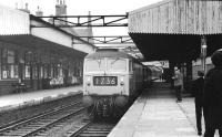 Galashiels [1st]: D1110 arrives at Galashiels on 13 April 1968 hauling the BR (Scottish Region) Easter Grand Tour. The special ran Edinburgh - Stafford and return via separate circuitous routes, (which are logge ...  Galashiels [1st]: An NCL lorry in Galashiels station forecourt in Spring 1971. At this stage, two years after closure, much of the physical infrastructure of the railway remained intact and BR provided a road-based par ...  Galashiels [1st]: D5302 arrives at Galashiels with train for Carlisle in 1966 past the impressive signal box at the north end of the station see image [[24013]]
|
|
The project director on the Borders Railway has said an eight-week closure of an 'extremely popular' walking and cycling route is 'unavoidable'.
The Black Path between Langlee and Tweedbank will be shut from 17 February. It is to allow a series of improvement works on the Redbridge viaduct over the River Tweed. (Permalink) Borders Railway Footpath 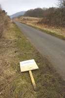 Tweedbank: View west along the Black Path from Tweedbank towards Galashiels on 11 April 2013. The sign reads NO WORKS WITHIN THIS AREA. 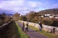 Redbridge Viaduct: Guardian photographer Murdo Macleod captures the paper's Scotland correspondent, Severin Carrell, interviewing CBR activist and Railscot contributor Bill Jamieson on the Red Bridge near Tweedbank on 1 ... 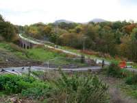 Redbridge Viaduct: Looking south along the Black Path towards the Red Bridge at Galashiels on 24 October 2013. Beyond stands Tweedbank with the Eildon Hills on the horizon. Photographed from the temporary path recently ... |
|
A £4m cycle and walking path with the longest cycling tunnel in Britain has opened with a mass cycle ride.
The Two Tunnels Greenway route opens up two former railway tunnels nearly 50 years after they closed. Almost 2,000 people attended the mass cycle to mark the opening of the route which runs from Bath to Midford. The path goes through Linear Park, on through the disused Devonshire and Combe Down railway tunnels, and over the Tucking Mill Viaduct. At over a mile long, the Combe Down tunnel will be the longest cycling tunnel in Britain and will feature an interactive light and sound installation. (Permalink) Combe Down Tunnel Footpath 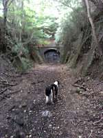 Combe Down Tunnel: This view shows the southern portal of Combe Down Tunnel - still awaiting restoration in September 2011! See image [[43820]] |
|
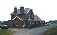
Moray councillors have agreed to accept an offer of over £97,000 for the former railway station at Ballindalloch.
The property, which stands on the Speyside Way long distance footpath, was leased by the council as a backpackers' hostel until it closed recently because of a problem with the water supply. (Permalink) Ballindalloch Footpath Speyside Way Strathspey Railway 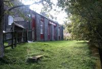 Ballindalloch: Platform view at Ballindalloch in September 2004, looking south west towards Grantown-on-Spey. The old station, which closed to passengers in October 1965, is seen here in use as a hostel. 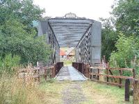 Ballindalloch Viaduct: Ballindalloch Girder Bridge on old Speyside Line now part of the Speyside Way.  Ballindalloch: The extensive goods yard at Ballindalloch, as seen on 2 November 1968 - freight services between Aviemore and Aberlour had been withdrawn the previous day. |