Lanarkshire and Dumbartonshire Railway
Introduction
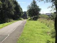
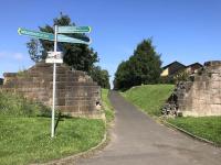
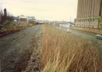
This line is closed except for a short section in Dumbarton from Dumbarton East Junction to Dunglass Junction [West] and another short, but disused, section between Dalmuir Riverside and Clydebank. The line was a protege of the Caledonian Railway.
Why built
This line connected the Caledonian Railway's system to shipyards, docks and factories on the north bank of the River Clyde. More than that, it encouraged the development of many of these works. It was built to compete with the existing North British Railway's system. It also carried passenger services from Glasgow to Possil and Dumbarton and connected with the line to Balloch.
As the line was built to compete with the existing network of the North British Railway, stations were built to a good standard with large station buildings with platform canopies.
Service
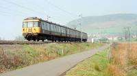
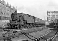
Passenger services ran from Glasgow Central Low Level to Possil and from Glasgow Central Low Level to Dumbarton Central, many continuing to Balloch Central.


Dates
Portions of line and locations
This line is divided into a number of portions.
Possil to Dumbarton
Double track passenger and goods line from Possil Junction to Dumbarton Central. Between Possil and Maryhill use was made of an old waggonway, rebuilt to railway standard.
This was the junction between the Hamiltonhill Branch (Caledonian Railway) and the Lanarkshire and Dumbartonshire Railway. This was a double track junction.
...
See also
Hamiltonhill Branch (Caledonian Railway)
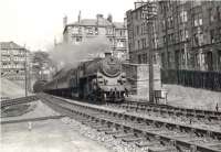
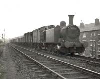
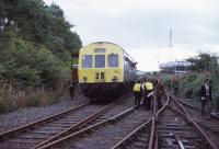
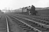
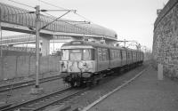
G H Robin collection by courtesy of the Mitchell Library, Glasgow 24/05/1958
Ewan Crawford 02/02/2008
Ewan Crawford 02/02/2008
G H Robin collection by courtesy of the Mitchell Library, Glasgow 24/06/1958
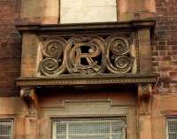
This station is closed but the street level station building and the former goods shed both remain standing. The station building, in red brick, presents a single storey, with two gable ends and attic onto Balmore Road. C and R are on tablets above windows on the south end of the frontage and a coat of arms above the north end. This building, which survived in other uses for many years, is ...
More details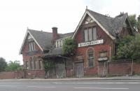
John Yellowlees 10/07/2023
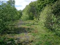
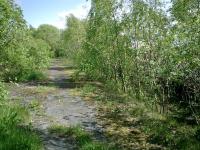
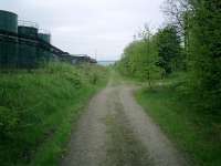
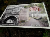
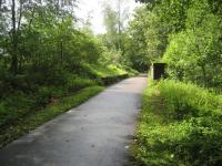
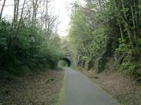
This is a disused double track tunnel between the former Maryhill Central and Possil stations. The tunnel is 808 yds long.
...
Alistair MacKenzie 12/12/1979
This signal box was to the north of Maryhill Central station and Maryhill Road and was south of the tunnel under the Forth and Clyde Canal and Tamshill Tunnel.
...
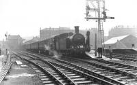
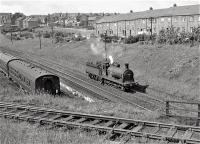
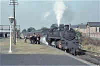
This was a four platform station. There were two through platforms and, on either side, two bay platforms for terminating services via Glasgow Central. These bays had carriage sidings alongside. Platforms were canopied. The majority of passenger trains terminated here, however the through lines were for passenger trains to Possil and goods and mineral trains running from [[Balornock ...
More detailsSee also
Glasgow Central Railway
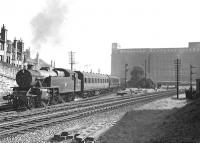
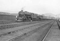
Brian Haslehust 03/10/1964
G H Robin collection by courtesy of the Mitchell Library, Glasgow 06/05/1961
G H Robin collection by courtesy of the Mitchell Library, Glasgow 25/07/1951
G H Robin collection by courtesy of the Mitchell Library, Glasgow 25/07/1951
This junction was west of Maryhill Central station. The station was on the east side of Garrioch Road and junction on the west side.
...
See also
Glasgow Central Railway
Veronica Clibbery 07/05/2011
Veronica Clibbery 07/05/2011
Rod Crawford 01/11/2015
Ewan Crawford //1988
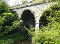
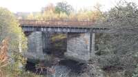
This signal box was located on the west to east part of the triangle of lines at Kirklee formed by Bellshaugh Junction (to the west), Maryhill Junction (east) and Kirklee Junction (south). To the immediate east the line crossed over the River Kelvin by a viaduct, one of a pair of viaducts carrying the lines to Maryhill Junction.
...
This goods yard was within the triangle of lines formed by Bellshaugh Junction (to the west), Maryhill Junction (east) and Kirklee Junction (south). The yard was approached from Bellshaugh Junction.
...
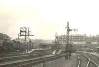
This was a four way junction. To the west were the lines to Dawsholm (north west, 1895) and Dumbarton Central (west, 1896). To the east were the lines to Maryhill Central and Balornock Junction (east, 1895) and Glasgow Central (south, 1896). The junction was on a cramped site on the south bank of the River Kelvin, the Dawsholm fork crossing the river immediately north west ...
More detailsSee also
Glasgow Central Railway
Robin McGregor 24/09/1964
Robin McGregor 24/09/1964
G H Robin collection by courtesy of the Mitchell Library, Glasgow 22/09/1959
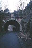
This is a disused double track railway tunnel between the former Kelvinside station and Bellshaugh Junction. The tunnel is 700 yds long.
...
...
Robin McGregor 24/09/1964
Alistair MacKenzie 12/12/1979
Colin Harkins 03/05/2008
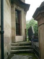
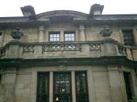
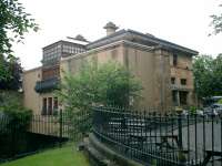
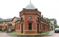
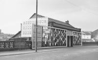
This was a two platform station on the south side of Great Western Road with a superb surface building by architect John James Burnet. The station was opened on the Lanarkshire and Dumbartonshire Railway, a protege of the Caledonian Railway.
...
Alistair MacKenzie //
Alistair MacKenzie 22/06/2007
Alistair MacKenzie 22/06/2007
Alistair MacKenzie 22/06/2007
This goods yard was operated by the Caledonian Railway although located on the Stobcross Railway, a North British Railway owned line. The Caledonian had running powers to the yard via Maryhill, Cowlairs and Sighthill.
...
See also
Stobcross Railway
Robin McGregor 22/06/1963
Robin McGregor 25/01/1964
Robin McGregor 11/09/1963
Robin McGregor 25/01/1964
This was a double track junction directly south of Crow Road Tunnel. This was the norther apex of a triangular junction, the other junctions between Partick West Junction and Partick East Junction. The signal box, opened with the junction, was in the 'V' of the junction.
...
Robin McGregor 01/05/1964
G H Robin collection by courtesy of the Mitchell Library, Glasgow 07/08/1957
G H Robin collection by courtesy of the Mitchell Library, Glasgow 02/08/1957
Ewan Crawford //1997
This was the western junction of a triangle of lines. The other junctions were Partick North Junction and Partick East Junction.
...
Ewan Crawford //1988
This station had an island platform with a building typical of the line. Entry was by subway from Ferryden Street.
...
Colin McDonald 12/07/2017
Ewan Crawford //1998
Ewan Crawford //
Colin McDonald 12/07/2017
This was an island platform station on a raised embankment. The Whiteinch Tramway passed below. The station building was typical of the line. It competed with the North British Railway's nearby Whiteinch Victoria Park which opened at the same time, 1896, on previously goods only branch.
...
Ewan Crawford //1988
Colin McDonald 12/07/2017
John Yellowlees 05/04/2019
Colin McDonald 12/07/2017
This junction opened in 1907 for the Rothesay Dock line, a joint Caledonian Railway and North British Railway railway.
...
See also
Rothesay Dock Branch (North British Railway and Caledonian Railway)
Ewan Crawford 09/01/2006
Ewan Crawford 09/01/2006
Ewan Crawford 09/01/2006
This was an island platform station. The station was just to the north of Yarrow's Shipbuilding, Engineering and Boilermaking Works partly on a bridge. The station was just west of Scotstoun West Junction. The station building was typical of the line.
...
See also
Clydeside Tramway
Ewan Crawford //1997
G H Robin collection by courtesy of the Mitchell Library, Glasgow 09/08/1957
Ewan Crawford 20/07/2011
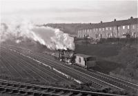
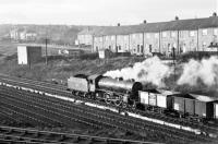
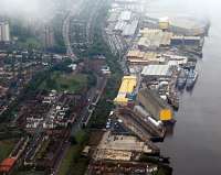
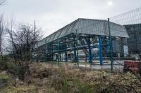
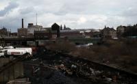
This coal fired power station was located to the south of the Lanarkshire and Dumbartonshire Railway which served it, via a reversal. Yoker Ferry station was to the immediate west. It was also accessible from the marshalling yard of Rothesay Dock. The site was bounded to the south by the River Clyde.
...
This was an island platform station with a building typical of the Lanarkshire and Dumbartonshire Railway. The line was on a raised embankment.
...
Alistair MacKenzie 09/05/2007
Alistair MacKenzie 09/05/2007
Alistair MacKenzie 09/05/2007
Ewan Crawford 12/06/2007
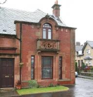
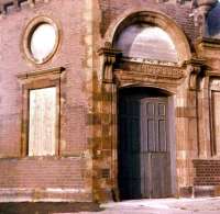
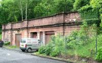
This station is closed, however the very fine booking office still stands.
...
John Furnevel 08/06/2010
John Furnevel 08/06/2010
Alistair MacKenzie //
Alistair MacKenzie //
This goods yard was between Kilbowie station and Clydebank Riverside. It was on the south/west side of the line. Approach was from the goods loop on the south side of Kilbowie station.
...
G H Robin collection by courtesy of the Mitchell Library, Glasgow 27/09/1957
This junction was at the east end of Kilbowie station. This station had goods loops on either side of its platform lines. The east end of the loop was controlled by Clydebank Goods Junction signal box on the north side of the line.
...
This swing bridge crossed the Forth and Clyde Canal in Clydebank, near Kilbowie Road station. It linked the Lanarkshire and Dumbartonshire Railway, on the south bank of the canal, to the Singer Works, on the north bank.
...
This was an island platform station on a raised embankment to the west of Kilbowie Road. The station building was typical of the line and there were not just platform lines but loops on either side of the island platform.
...
G H Robin collection by courtesy of the Mitchell Library, Glasgow 27/09/1957

Ewan Crawford 09/01/2006
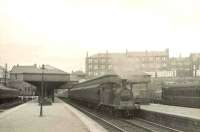
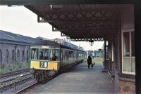
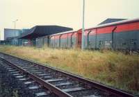
This was a spacious four platform station, two being terminal platforms on the north side and the main route being served by an island platform. Access was by footbridge from Auld Street.
...
Brian Haslehust 03/10/1964
Brian Haslehust 03/10/1964
Alistair MacKenzie 04/05/2007
Alistair MacKenzie 04/05/2007
This short lived signal box was west of Dalmuir Riverside. It controlled access to the Clyde Trust's Dalmuir Dredger Works, the west end of Beardmore's Dalmuir Naval Construction Yard, and the Dalmuir Sewage Purification Works. These were on the south side of the main line and on the north bank of the River Clyde.
...
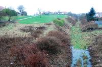
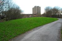
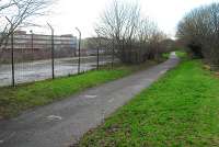
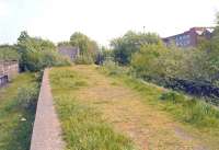
This siding was on the south side of the Lanarkshire and Dumbartonshire Railway midway between the former Dalmuir Riverside (to the east) and Old Kilpatrick stations. Approach was from the west. The siding was served by trains from Chivas Bros Siding [Keith].
...
Alistair MacKenzie 04/05/2007
Ewan Crawford 25/02/2020
Ewan Crawford //1987
This was a two platform station in slight cutting below road level. There were Caledonian Railway style buildings on the platforms (the westbound platform building was the larger) and ramps to street level. The passenger station was on the north side of the Erskine Ferry Road.
...
Roger Geach Collection 24/08/1974
Ewan Crawford 25/02/2020
Alistair MacKenzie 25/04/2007
Alistair MacKenzie 25/04/2007
This quay was on the north bank of the River Clyde east of Bowling and west of Old Kilpatrick. It was named for Robert Donald of Mountblow House. It was the northern pier of a former route of the Erskine Ferry (Erskine House is just across the Clyde and the landowner Lord Blantyre owned land on either side of the river) known as the Ferrydyke and additionally saw use as a coal ...
More details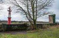
Ewan Crawford 25/02/2020
The Lanarkshire and Dumbartonshire Railway had a second lesser known swing bridge which was directly south of the main Bowling Swing Bridge. A line from Bowling Harbour Signal Box ran west to serve the east end of Bowling Basin and then cross the lower basin to reach the quaysides in Bowling Basin and Bowling Harbour. Here it connected with the sidings of the [[Glasgow, Dumbarton and ...
More details
Ewan Crawford 25/02/2020
Ewan Crawford 25/02/2020
G H Robin collection by courtesy of the Mitchell Library, Glasgow 12/04/1958
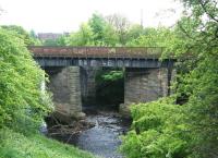
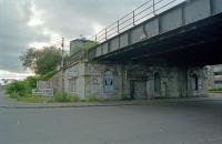
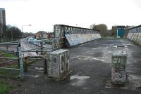
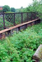
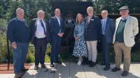
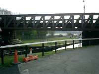
This double track swing bridge crosses the Forth and Clyde Canal between the upper and lower basins at Bowling. A signal box was mounted above the running lines to the immediate west of the bridge. The pivot of the bridge was just to the east of the box and the bridge's east end swung north. The bridge was moved hydraulically. It carried the 1896 Lanarkshire and Dumbartonshire Railway. The ...
More details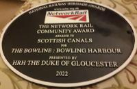
John Yellowlees 06/12/2022
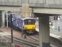
Network Rail 11/07/2023
John Furnevel 08/06/2010
Alistair MacKenzie 13/04/2007
This was an island platform station. The station building was typical of the line. The railway was to the north of and above the town and Bowling Harbour. Entrance was by a subway with a station frontage at street level on the south side of the line. The subway emerged at the west end of the platform.
...
John Yellowlees 08/02/2022
John Furnevel 08/06/2010
Alistair MacKenzie 13/04/2007
John McIntyre 02/06/2019
These sidings were west of Bowling [CR] station. These were accessed from the west by reversal, there was a ground frame.
...
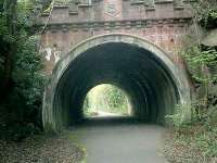
This very short tunnel, with highly ornamental portals with armorial plaque at the east, carried the eastern driveway to Auchentorlie House, to the north west. The tunnel was to provide sufficient length to blind the railway from the driveway to avoid scaring horses. The tunnel was west of Bowling [CR].
...
Alistair MacKenzie 13/04/2007
Alistair MacKenzie 13/04/2007
Ewan Crawford //
Ken Strachan 14/07/2015
Ewan Crawford //1990
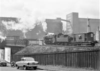
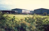
This gas works was opened by the Dumbarton Town Council Gas Department in 1923. The works was initially on the north side of the Lanarkshire and Dumbartonshire Railway and expanded in 1954 to include a further gasometer on the west/south side of the line. It was absorbed by the Scottish Gas Board in 1949.
...
This junction opened with the line to serve Leven Shipbuilding Yard (the Denny's shipyard thus the original name of Denny's Siding). The branch was on the south/west side of the line, approached from the east, as the westbound main line curved north towards Dumbarton East.
...
Ewan Crawford //1991
Ewan Crawford //1991
Alistair MacKenzie 06/03/1980
Mark Bartlett 03/08/2017
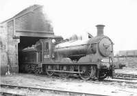
This single ended two road shed was close to Dumbarton East station. It was located in the 'V' of the junction between the main line and the goods line approaching Dumbarton East Goods (also known as Dumbarton South Goods). The shed was approached by reversing from the goods yard (to the west).
...
G H Robin collection by courtesy of the Mitchell Library, Glasgow 26/11/1960
This goods yard, also known as Dumbartion South Goods, was on the south side of the line curving from Dumbarton East to Dumbarton Central. It was approached from the south (the west side of Dumbarton East).
...
Ewan Crawford //1996
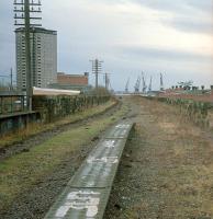
This is an island platform station. The station features street level entry, which formerly had a booking office. The island platform building (similar to those at Dumbarton Central) no longer exists but a waiting shelter is provided.
...
...
David Panton 14/10/2017
John McIntyre 22/11/2011
Mark Bartlett 03/08/2017
This junction was directly east of Dumbarton Central station. It was formed in 1896. Here the former Caledonian and Dumbartonshire Junction Railway of 1850 (now owned by the North British Railway) was met by the newly opened Lanarkshire and Dumbartonshire Railway.
...
See also
Caledonian and Dumbartonshire Junction Railway
G H Robin collection by courtesy of the Mitchell Library, Glasgow 12/04/1958
G H Robin collection by courtesy of the Mitchell Library, Glasgow 12/04/1958
Ewan Crawford //1987
G H Robin collection by courtesy of the Mitchell Library, Glasgow 12/04/1958
Stobcross to Partick
Double track passenger and goods line from Exhibition Centre to Partick West Junction.
This station is at the east end of a flying junction from Partick, leading to an unusual V shape.
...
See also
Glasgow Central Railway
David Bosher 06/09/2022
...
Bill Roberton /02/1988
David Panton 07/07/2018
David Panton 13/07/2019
This junction was located in the tunnel just west of Stobcross station (now Exhibition Centre).
...
This double track tunnel originally ran from Kelvinhaugh Signal Box to the west to Stobcross station to the east. It closed in 1965. The original tunnel is 755 yds long.
...
This signal box was on girders above the Lanarkshire and Ayrshire Railway in a short stone lined cutting north of Kelvinhaugh Street. Yorkhill Tunnel was to the north, Kelvinhaugh Tunnel to the south. ...
More detailsThis mill near Partick was on the east bank of the River Kelvin. It was built on the site of the Bunhouse Mill.
...
This was an island platform station with a street level building on Benalder Street and platform building.
...
Martin MacGuire 20/05/2023
John Clark //1980
David Murray-Smith /09/1959
This junction was to the immediate east of Partick West station, that station being built on the lines approaching the junction. This was the east junction of a triangular junction, the northern apex being Partick North Junction and western Partick West Junction.
...
See also
Clydeside Tramway
Robin McGregor 25/03/1964
Ewan Crawford //1988
Ewan Crawford //1988
Ewan Crawford //1988
Ewan Crawford //1988
This was the western junction of a triangle of lines. The other junctions were Partick North Junction and Partick East Junction.
...
Ewan Crawford //1988
Partick East Junction to Partick North Junction
Partick East Junction to Partick North Junction.
This was a double track junction directly south of Crow Road Tunnel. This was the norther apex of a triangular junction, the other junctions between Partick West Junction and Partick East Junction. The signal box, opened with the junction, was in the 'V' of the junction.
...
Robin McGregor 01/05/1964
G H Robin collection by courtesy of the Mitchell Library, Glasgow 07/08/1957
G H Robin collection by courtesy of the Mitchell Library, Glasgow 02/08/1957
Ewan Crawford //1997
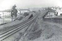
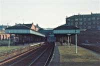
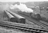
This was a five platform station built on two curves of a triangular junction. There were three platforms on the east-west route from Dumbarton Central to Glasgow Central Low Level (two westbound on either side of an island platform and one eastbound) and two platforms on the east-north route from Possil to Glasgow Central Low Level.
...
Ewan Crawford //1988
Ewan Crawford //1988
Ewan Crawford //1988
Ewan Crawford //1988
This junction was to the immediate east of Partick West station, that station being built on the lines approaching the junction. This was the east junction of a triangular junction, the northern apex being Partick North Junction and western Partick West Junction.
...
See also
Clydeside Tramway
Robin McGregor 25/03/1964
Bowling Harbour Branch
This short branch left the main line east of Bowling station and ran on the south side of the line on a descent to meet the lower canal basin on its east side. The line continued by means of a low level swing bridge over the canal, to the immediate south of the more famous and still standing swing bridge, to reach exchange sidings with the Glasgow, Dumbarton and Helensburgh Railway and serve the harbour quayside.
The Lanarkshire and Dumbartonshire Railway had a second lesser known swing bridge which was directly south of the main Bowling Swing Bridge. A line from Bowling Harbour Signal Box ran west to serve the east end of Bowling Basin and then cross the lower basin to reach the quaysides in Bowling Basin and Bowling Harbour. Here it connected with the sidings of the [[Glasgow, Dumbarton and ...
More detailsEwan Crawford 25/02/2020
Ewan Crawford 25/02/2020
G H Robin collection by courtesy of the Mitchell Library, Glasgow 12/04/1958
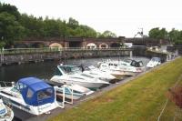
This tidal harbour, today associated with old hulks lying in the mud exposed at the low tide, is the western entry to the Forth and Clyde Canal. It is enclosed by two structures, a dyke to the west (built 1856 by the Clyde Trustees) and the eastern (built 1846) which was a long timber quayside, now almost totally gone. It was laid out in 1846 when a new sea lock from the western side of ...
More detailsSee also
Caledonian and Dumbartonshire Junction Railway
Rutherglen Terminus
Although not part of the line, but located on the Glasgow Central Railway, platforms 3, 4 and 5 (old numbering) at Rutherglen were developed to be terminal platforms for trains from Balloch and Dumbarton.
This junction was replaced by the present Rutherglen North Junction, the present junction being south of the former Clydebridge Junction (the original Rutherglen North Junction [1st] was further south).
...
See also
Dalmarnock Branch (Caledonian Railway)
Glasgow Central Railway
The Switchback (Caledonian Railway)
G H Robin collection by courtesy of the Mitchell Library, Glasgow 17/05/1957
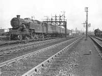
These carriage sidings were opened in 1896 as part of the Glasgow Central Railway. There were three bay platforms just to the west and services both started and ended at Rutherglen [4th]. The terminal platforms and carriage sidings were controlled by Rutherglen Noth Junction box which looked out over the area.
...
With the opening of the Glasgow Central Railway a further six platforms were to open at Rutherglen, in addition to the existing six (two on the west to north curve and four on the mainline).
...
Books